Open topic with navigation
Data Feed In
To configure enterprise data imported into XECUTE, click the Data Feed In icon.

Data Feed In allows for the configuration of data that will be consumed by XECUTE from RPM Enterprise Planning Framework (EPF). Examples include schedule guidance, drill hole data, fleet management system GPS data and stockpile inventories.
XECUTE checks the Data Feed In every minute. If there is a problem or issue (incorrect datasource or definitions and so on), the retry mechanism changes to once every five minutes, second retry is every 30 minutes then every six hours (if it works in a retry, it goes back to one minute refresh interval).
After the Data Feed In has been configured, a panel to the right will preview the latest matching dataset that exists in EPF.
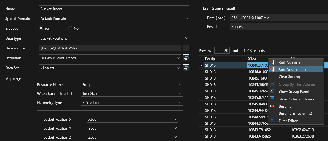
The image below shows a Data Feed In configuration panel for Bucket Positions. The mappings must be completed for a valid configuration. Additional Data Feed In fields that are not directly mapped are listed under Additional Attributes. If a mapping is not valid a Red cross is shown for the field.
The image below shows the preview panel with Last Retrieval Result messages and the preview grid. The preview columns can be sorted and filtered by clicking in the column header cells (shown here with the available controls). The Last Retrieval Result panel shows the date the data was retrieved and any associated error messages pertaining to the dataset.
- To add a new Data Feed In, click
 , then enter a unique Name for the data feed.
- For selected Data Feed In types the Spatial Domain can be selected. For types not associated with Spatial Domains this field is hidden.
- Select whether the Data Feed Is active by selecting Yes. An inactive Data Feed will not send data to XECUTE.
- Click the drop-down arrow beside Data Type and select the type of Data Feed In. The data types are pre-configured data layouts for import into XECUTE. See the table below.
- Select a Data source and Definition. The entries in the list are populated from EPF and can be configured using Integration Management Studio. The Data source is the location of the data and the Definition ( EPF Dataset Definition (DSD)) is the list of fields and their data type .
- [OPTIONAL] Set the Data Set to fetch from the list of available data set creation dates. There may be more than one dataset loaded into EPF, XECUTE by default will fetch the latest dataset shown as <Latest> in the selection. To override this behaviour, select the desired dataset. XECUTE will continue to use the selected dataset until the selected option is changed back to the <Latest> option.
-
Map the relevant dataset definition field (in the drop-down lists) to each XECUTE Mappings field. Any unassigned dataset fields are listed in the Additional Attributes section. The dataset definition field data type will be validated against the XECUTE mappings field data type.
- Click the Save icon. The data feed is now available to send data from EPF to XECUTE.
# - Mandatory fields
^ - applicable to Staged Stockpile nodes
Geometry - The spatial data of a data feed can be represented as OGC compliant Well Known Text (WKT) which is an ASCII format, Serialised Spatial Data (data published from other RPM products) or by individual fields to hold the coordinate values, for example drill hole or machine positions. If Well Known Text is selected, a single text field is available to hold the ASCII data.
| Bucket Positions |
Loader bucket position data used to trim the activity areas.
-
Resource Name# - the XECUTE resource name.
- When Bucket Loaded# –the bucket loading datetime.
- Geometry Type – the format of the geometry data
- Geometry# – the fields that hold the geometry type data.
- Additional Attributes – Dataset Definition fields that have not been mapped. These will appear as columns in the Bucket Positions tab in XECUTE.
|
| Calendar Field |
External period based data used in Fixed Plant Maintenance events
-
Calendar Field Name# - The field name. It must also be configured in XECUTE Config > [Site Settings] > Calendar Fields
-
Start Date# - The start date/time of the calendar event
-
End Date# - The end date/time of the calendar event
-
Calendar Field Value# - The value assigned to the calendar field name
|
| Drill Hole - Actual |
Drill hole data from a fleet management system for display in XECUTE. Spatial data supports linestrings.
-
Identifier# – the unique id of the drill hole.
- Status# – the status value/code.
- Activity Area Name –the activity area name associated with the drill hole.
- Last Updated on - the date the data was recorded.
- Geometry Type - the format of the geometry data.
- Geometry# – the fields that hold the geometry type data.
- Additional Attributes – Dataset Definition fields that have not been mapped. These will appear as columns in the Drill Holes tab in XECUTE.
|
| Drill Hole - Plan |
Drill hole data from a planning system for display in XECUTE. Spatial data supports linestrings.
- Identifier# – the unique id of the drill hole.
- Sequence – the drill sequence number.
- Activity Area Name – the activity area associated with the hole.
- Status – the status value/code.
- Duration – the drilling duration for the hole.
- Diameter – the drill hole diameter in mm/inches (used for visualisation in XECUTE).
- Length – the drill hole length.
- Last Updated on – the date the data was recorded.
- Geometry Type - select the format of the geometry data.
- Geometry# – the fields that hold the geometry type data.
- Additional Attributes – Dataset Definition fields that have not been mapped. These will appear as columns in the Drill Holes tab in XECUTE.
|
| Dump Reconciliation |
Inventory checkpoint data to set material flow stockpile and dump initial values.
-
Dump name# – name value in the Dataset Definition field must match the XECUTE dump name (case-insensitive).
-
Measure date# – the date of the checkpoint.
- Volume# – the volume of the dump checkpoint.
- Mass# – the mass of the dump (must be <= stockpile capacity).
- Estimated fill rate (vol) – fill rate per hour from checkpoint measure date to the schedule start date.
- Estimated fill rate (mass) – fill rate per hour from checkpoint measure date to the schedule start date.
- [principal fields] – Non-expression based principal fields can be mapped to data feed in fields.
- Additional Attributes – Dataset Definition fields that have not been mapped to any of the defined fields above.
|
| External Schedule |
External schedule data is mapped to the following fields and used in the Gantt Reporting feature:
-
Resource Name# - The name of the item to schedule
-
Scheduled Start Date# - The start date/time of the schedule event
-
Scheduled End Date# - The end date/time of the schedule event
|
| LIFO Stockpile Reconciliation |
Inventory checkpoint data to set material flow LIFO parcel initial values. Stockpiles can be regular 'averaged' type stockpiles or staged stockpiles with one or more piles.
-
Stockpile name# – name value in the Dataset Definition field must match the XECUTE stockpile name (case-insensitive).
-
Measure date# – the date of the checkpoint.
- LIFO pile name# – the name of the LIFO pile as configured in the material flow to enable imported data to link to the pile.
- LIFO parcel index# – the index of the parcels in the pile.
- LIFO parcel name – the name of the parcels in the pile.
-
Volume# – the volume of the parcel checkpoint.
-
Mass# – the mass of the parcel checkpoint.
-
[principal fields] – Non-expression based principal fields can be mapped to data feed in fields.
-
Additional Attributes – Dataset Definition fields that have not been mapped to any of the defined fields above.
|
| Maintenance Order |
Maintenance orders from ERP systems.
-
Resource Name# – the Name of the Resource. The name must match the XECUTE Resource name (case insensitive).
-
Order Number# – a unique identifier or the order.
-
Order Description – test description.
-
Start Date# – the start date of the maintenance work.
-
End Date# – the end date of the maintenance work.
- Additional Attributes – Dataset Definition fields that have not been mapped to any of the defined fields above.
|
| Resource Position |
Fleet Management System tracking data to show resource positions in the 3D Scene.
-
Resource Name# – the XECUTE resource name.
-
Last Updated on – the date associated with the resource position.
-
Heading – the orientation of the resource (in degrees from true north).
-
Geometry Type – the format of the geometry area.
-
Geometry# – the fields that hold the geometry type data.
-
Additional Attributes – Dataset Definition fields that have not been mapped.
|
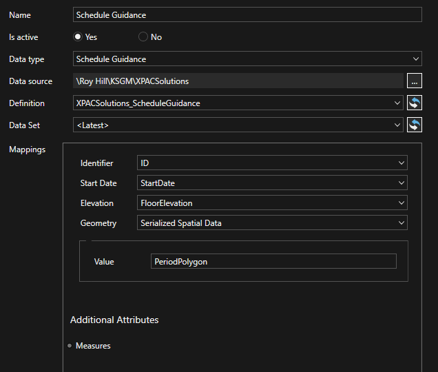
| Schedule Guidance |
Activity area spatial data and attributes from external planning systems.
- Identifier# – the unique id of the guidance shape.
- Start Date# – the schedule date of the guidance shape.
- Elevation – the mining level floor elevation.
- Geometry Type – the format of the geometry data.
- Polygon WKT# – [For WKT Geometry Type] the WKT string data of the polygon .
- Solid WKT – [For WKT Geometry Type] the WKT string data of the solid (as TIN).
- Value# – [For Serialised Spatial Data Geometry Type] field name that holds the serialised spatial data.
- Additional Attributes – Dataset Definition fields that have not been mapped. These will appear as columns in the Guidance tab in XECUTE.
The EPF Dataset Definition that holds the schedule guidance data has specific requirements. The Identifier, Start Date and Elevation fields must be keys in the Dataset Definition.
If the guidance data is from an external source, the geometry data must be in OGC-compliant WKT format and a key data type.
If the guidance data is from RPMGlobal Solutions, the geometry is serialised spatial data.
|
| Stockpile Reconciliation |
Inventory checkpoint data to set material flow stockpile initial values. Stockpiles can be regular 'averaged' type stockpiles or staged stockpiles with one or more piles.
-
Stockpile name# – name value in the DSD field must match the XECUTE stockpile name (case-insensitive).
-
Measure date# – the date of the checkpoint.
-
Volume# – the volume of the stockpile checkpoint.
-
Mass# – the mass of the stockpile checkpoint (must be <= stockpile capacity).
-
Estimated fill rate (vol) – fill rate per hour from the checkpoint measure date to the schedule start date.
-
Estimated fill rate (mass) – fill rate per hour from the checkpoint measure date to the schedule start date.
-
Staged stockpile pile name^ – the name of the pile as configured in the material flow to enable imported data to link to the pile.
-
Stages stockpile pile status^ – whether the pile is Building or Depleting at the checkpoint timestamp.
-
Staged stockpile build name^ – the name of the build if designated pile build specifications are configured in the material flow.
-
[principal fields] – Non-expression based principal fields can be mapped to data feed in fields
-
Additional Attributes – Dataset Definition fields that have not been mapped to any of the defined fields above.
|