Exporting spatial data using the Spatial Data Wizard |

|

|
|
Exporting spatial data using the Spatial Data Wizard |

|

|
Exporting spatial data using the Spatial Data Wizard |

|

|
|
Exporting spatial data using the Spatial Data Wizard |

|

|
XPAC lets you use the Spatial Data Wizard to export spatial data from your XPAC project for use in other programs (for example, Vulcan, AutoCAD, Datamine), or other XPAC projects. You can use the Spatial Data Wizard to export spatial data in the following file formats:
|
If required, you can also use an XCM to export spatial data in another format (see the XCM programming guide or contact RPMGlobal for more information). |
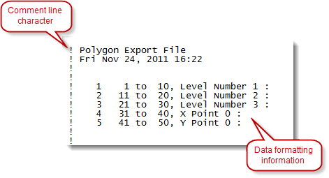
When you export spatial data as a delimited or fixed width file, XPAC automatically inserts a header in the content of the document. If you import this spatial data into another XPAC project, XPAC can use the information contained within the header to determine how the data has been formatted in the file, for example:

Polygon file headers can also be used to control how polygons are exported. For example, you may have an existing polygon export file that you want to update. If this file is selected as the export file, then the header will be read and used for the initial field setup in the polygon export template. Then when you proceed with exporting the polygons, the selected file will be over-written.
To save time, you may want to consider saving your export settings when using the wizard. You can do this by clicking Load/Save Template in the wizard. XPAC saves your settings to the database so that you can access it at a later time, or in another part of the project. See Using settings templates to import and export spatial data for more information.